
So here I begin my series of articles today on the history of my Cotentin ... I hope to avoid errors ... But I'm only an amateur historian ... so, I beg you to please forgive my errors ...
I love my area, you know ... I love my city, Isigny-sur-Mer ... You may say, the Cotentin is the English Channel, Calvados not ... And I answer: if you examine carefully the map you will see qu'Isigny-sur-Mer is just across the border Cotentin -Bessin ... .... and saw that Mom is a pure Cotentine. ... we opted for this country ... But we like the Bessin too!

And then Cotentin is wild is Viking's rebel!
is the finger turned towards England to remind him that it is Norman ... .. and not the opposite!

The Peninsula Cotentin thus extends between the estuary of the Vire (this is where I live ...) and the mouth of the Ay (c. Debt country carrots ...) forming a peninsula and forms the northern department of La Manche. Sometimes simply called Cotentin , it is now often referred to, to avoid confusion, North Cotentin or country Cotentin , which excludes the city of Coutances and southern Cotentin history!

The peninsula is clearly bounded by the sea to the west, north and east, and a vast area of marsh flooded south-east (it's here!) . She So sometimes been mentioned in history as an island, because the strip of marsh cutting the northernmost part of the Cotentin the rest of the Normandy south East, which gave the peninsula to the construction of modern roads, inaccessible in winter. Hence her wild side!
The regional park of Marais du Cotentin and Bessin occupies a large part of the peninsula ... ... and I live!

The peninsula of Cotentin is divided into four "countries" Historical
In the northwest, The Hague. ...
the center, the Plain Region of farmland ... ...
the south of the pass Cotentin or Bauptois , marshland and heathland ... ... ... ....
The Cotentin in its broadest definition includes two northern third of the department Channel, the southern third is composed of all of Avranches, and a small portion of the west of Calvados, the Bocage Virois ... ... ... ...

Geologically, the Cotentin is part of the Armorican ... ... ... ...

the west Coast Islands faces the islands Anglo-Norman and Chausey which it is connected by a ferry service from Carteret and Granville . The islands Chausey facing Granville are part of the Cotentin (the card is légendée en Patois Jersiais ...) ... ... ...

Le once Blanchard separates the Cape of Hague and Alderney ...
And the passage of the coastal harbors Rout and the Isle of Jersey ...
The largest city Cotentin is the port of Cherbourg on the north coast , former grand military port, it became a major port for connections to England and Ireland ...
Well, now you my Country is well !!!!!!!!!!!
Taking History ....
**************************
LA PREHISTOIRE
We have no " Lucy " Cotentine ! The land is too acidic to retain human remains ... The Earth's eat!
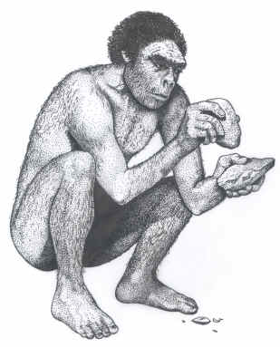 |
| DRAWING MERA BY HERTEL http://lithiccastinglab.com/ |
Early man, Homo Erectus then Sapiens , appeared in our region during the Middle Paleolithic to - 250,000 at the beginning of the preliminary -last glaciation ( Riss ), they'll leave at the height of glaciation to 180,000 ... .. The location of coastal sites shows the importance of the sea (fish, shells, flint, ...) for those men who do not live only for hunting large land mammals ... ...
The earliest Paleolithic sites in the North Cotentin are three in number:
A small deposit discovered near Cherbourg (the Saline Equeurdreville ...
Port Pignot ( Fermanville in Val de Saire ) ...
La Roche Gélétan (St. Germain-des-Vaux in the Hague ) ...
They are on fossil beaches currently located at 10 m above sea level, they date from approximately the same period (250,000) and include successive levels of occupation. We have discovered the limits of huts, fireplaces and areas of flaking stone ... ...
The Neanderthals return home to - 110 000. They will leave to - 75 000 at the beginning of the last glaciation (Würm ). You can find traces of regular crossings between Saint-Vaast -la-Hougue and Rozel . The sites are located approximately 4 m above sea level ... ... ... ... ..
The site of Saint-Germain-des-Vaux is the most important ... it extends over 1 km and comprises two levels: remains of an ancient beach located 5 m above sea level and large deposits of the last glaciation. Furniture found on this site: flint (scrapers, denticulate , strips ...), homes coals (pine and birch) ... ... ... ....
There are few places in the Mesolithic (10,000) on the West Coast: the Rozel, Flamanville (site of NPP) and above Auderville ... .
They dominated the low plain that connected while some islands Anglo-Norman (Jersey, Minquiers the Ecrehos ) to the mainland ... ... ..
On the East Coast, there Montfarville . It has been found in these pools, homes and industry products lithic (50,000 items) ... ... ... ...
 |
| Plate from the publication of Henry Menut in Volume XXV Memoirs of the Science Society of Cherbourg. http://www.societesciencescherbourg.org/ |
5500, few saw the Neolithic incursions pre-Celtic in Lower Normandy of Danubians Type "gracile Mediterranean" (strange name!) and from - 4500 to other peoples of the area between the Danube and the upper valley of the Rhine . They provide breeding, farming techniques, organization of Habitat, slopes and hedgerows, pottery, basketry, weaving, a religion based on ancestor worship, megaliths ...... ....
rare during the first two periods of the Neolithic remains are numerous to the late Neolithic (- 4000 / - 2000): menhirs, dolmens, covered walkways, cairns ...
 |
| Stones Pouquelées http://www.payscotentin.net/ |
We note that a number of collective graves were installed in direct view of the sea ( Vauville , stones pouquelées below, Fermanville , Flamanville and to a lesser extent Maupertus and Vierville ), others are far from dozens of miles ... ... ... ....
Among the
s it, we should note the site exceptional for its density, Rocheville near Bricquebec , where no fewer than four collective graves (only one was received) within a few hundred meters ... ... ... ..
The mounds are concentrated most preferably in the Hague where we can meet half an dozen unexcavated and some ignored. Some of them have been excavated in the last century or the beginning of this century. A half-dozen have been destroyed outright in a few minutes when the construction of the center of the Cogema in the 60s!
A mention must be made in the barrow Vierville near Carentan , one of the very few to have undergone a comprehensive scientific study ... ... ... ... ....
Regarding the menhirs, no alignment has been identified with certainty in the Channel even if we could talk sometimes ... ... cromlech
The real difficulty in identifying a menhir in itself makes it perilous to study their distribution. The establishment, in the fields, " scratch "vertical stones for cattle (yes, that cows can scratch my back ....) is an example of a common source of confusion. Delimitation of plots, signaling hubs or fords is were also made at all times by stones. The "currency" of Carneville or Saint-Pierre Church are fine examples to see here ...:
A Bronze Age (- 2000 / - 800) of Celtic new immigrations take place. However the channel is a remote area, more towards the sea towards the interior of Gaul, and it will be quite little celtisée at that time. Some sites exist: Nouainville , Sainte-Croix-Hague , Teurthéville - Hague , Couville , Tatihou ,.... where it was found metal objects, remnants of habitat, homes, ceramics and lithic material ...
two entrenched camps can be dated from this period: the Hague - Dike (to be reused by the Norse) and Castel Guerard ( Flamanville ) ...

We arrive at -550 and the Celtic tribe of Unelli moved into
.gif)
0 comments:
Post a Comment